 Hurricane Dorian 2019
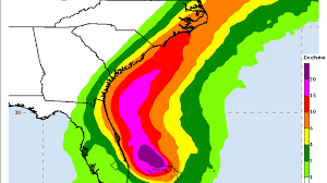
Hurricane Dorian is a category 5 with 165 MPH wind speed. Wind guests in the Grand Bahama Islands are 200 mph. Expected to hit South Carolina end of week 9/6/2019.


Tropical Storm and Hurricane Information
Horry County Hurricane Information
Emergency-Management
Online-Services/Know-Your-Zone
In South Carolina ONLY the Governor has the authority to order an evacuation for hurricanes. Once an evacuation order has been issued, it can be enforced as law.
The hurricane season officially begins June 1 and runs until Nov. 30, with its peak between mid-August and late October.
If hurricanes threaten the Myrtle Beach area and an evacuation order is ordered, here’s what you need to know:
Mandatory Evacuation Procedures
Lane reversal: When an evacuation order is issued, lane reversals occur for two sections of U.S. Highway 501 from S.C. 544 to S.C. 378 and U.S. 501 from S.C. 22 to the U.S. 501/576 split in Marion.
Officials say once you get into a lane reversal pattern, you will not be able to get back out. Do not enter a lane reversal pattern unless law enforcement directs you to.
If the governor calls for mandatory evacuations, he will likely do so by picking zones to evacuate.
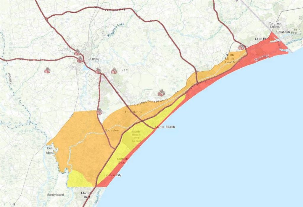 Zone locations in Horry County:
Zone A (red): South Hampton/Kingston Plantation Zone
Zone B (yellow):
Zone C (orange):
Looking Back at Myrtle Beach Hurricanes
 Hurricane Ian 2022
Hurricane Ian made landfall in Georgetown, South Carolina on Friday September 30, 2022 at 2:05pm as a category 1 storm and was downgraded to a post-tropical cyclone at 4:42pm with winds at 70mph. It moved through South Carolina at about 15 mph.
As of 7:00pm South Carolina had 180,604 power outages across the state.
Flooding was reported up to 5 – 7 feet, and inland flooding was 4 – 8 inches. A storm surge of 6.2 feet and a storm tide of 5.17 feet above Mean Higher High Water (MHHW) was observed at 1:36 p.m. Friday, September 30. This was that location’s third highest water level on record – far below the 8.77 feet recorded during Hurricane Hugo in 1989, but still enough to produce significant flooding.
 Hurricane Isaias 2020
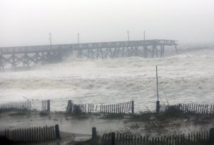
Hurricane Isaias made landfall north of Myrtle Beach on Monday night, 8/2/2020 with it moving from tropical storm to hurricane at 8 p.m. Winds reached 67 mph in Georgetown County. The National Weather Service recorded 3.11 inches of rain in North Myrtle Beach, 2.12 in Myrtle Beach and 3.03 inches in Conway. Isaias nearly caused a record-breaking high tide of 10.18 feet at the Springmaid Pier. Heavy winds and gusts exceeding 50 miles per hour knocked out power lines and caused structural damage. The eye of the storm moved over Myrtle Beach with winds reaching 85 mph.
Hurricane Dorian 2019
Hurricane Dorian is a category 5 with 165 MPH wind speed. Wind guests in the Grand Bahama Islands are 200 mph. Expected to hit South Carolina end of week 9/6/2019.
 Hurricane Irma 2017
Hurricane Irma was a tropical storm by the time she hit Myrtle Beach. Wind guests in Georgetown were 61 mph.
Rainfall in a 24 hour period was 4.52 in.
 Hurricane Matthew: October 2016
Catagory 5
Horry County highest wind gust: 61 mph and saw over 11 in. for storm total precipitation.
Georgetown County saw over 5 in. for storm total precipitation.
 Hurricane Charley: August 2004
Catagory 4
Wind guests reached 75 mph along the Grand Strand
Rainfall up to 4.25 in Conway

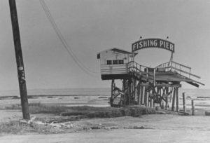
Hurricane Floyd: September 1999
Catagory 2
Most of the Springmaid pier was lost
Winds reaching 105 mph
20″ of rain
 Hurricane Hugo: September 1989
Catagory 5
Winds at 85 mph
12 ft high walls of water
 Hurricane Hazel: October 1954
Catagory 4
Waves reached 50 ft
Winds reached 130-150 mph